About GIS Surveyor - Land Survey and
The application comes on a subscription basis. You will be charged only after 3 days of free trial. Also, we would really appreciate if you reach us with your issues before rating us. To raise a ticket, find a link below !
The application comes on a subscription basis. You will be charged only after 3 days of free trial. Also, we would really appreciate if you reach us with your issues before rating us.
To raise a ticket, find a link below ↓↓
GIS Surveyor is a
GIS application meant for
GIS survey ,
GIS Data handling ,
data collection , analysis, and planning before execution of a project. It allows professional surveyors with an opportunity to collect more accurate survey data in a stipulated time frame. This application is also a GIS
remote sensing application that can be used for
GIS Mapping.
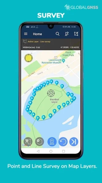
GIS Surveyor is a GPS/GNSS based survey application that uses GPS data collection. It will be used for various types of environmental surveys and field surveys while also enabling the GIS data collection to be faster and efficient.
This application can be used for
Field Survey ,
Land Survey ,and other surveys which includes field data collection including
internal GPS or
external GPS .
-
Top GIS Survey Application features:
-
GIS data collector
-
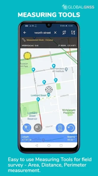
Calculate the area and distance .
-
GPS land area calculator
- Attributes can be imported from any other project or device.
-
Survey using images for any location is available, with multiple export options.
- One set of attributes can be used across multiple surveys.
- Various
Export file formats for GIS data are
CSV, KML, and GeoJSON .
- Post process of data can be performed with software like
ArcGIS, ArcGIS online or qGIS.
- With external
Bluetooth GPS/GNSS device connected,
NTRIP/RTK data can be utilised for accuracy.
-
Survey on
online gis maps , and
GIS offline maps (supports
mbtiles )
-
WMS and WFS Surveyor tiled maps are supported, load topographic and orthophoto maps, geological surveys, cadastral information.
- Currently 4 methods of
data collections are supported,
GPS / GNSS location , map cursor location,
GIS Tracker , point projection using angle and distance.
-
Mapit GIS survey on multiple kinds of GIS maps.
- Direct
export to Dropbox,Google Drive, FTP location .
-
Import point, line and polygon layer in
CSV, KML or geojson file.
- Possibility to view multiple layers including points, lines and polygons at the same time.
- Possibility to group the data into survey layers - each survey layer may have a default set of attributes.
- Create new polygon or line features and measure details like area, length and perimeter.
- Backup management.
- Export in
.SHP format .
- Export in
GPX format. .
- Works with
GEOID Model to provide elevation for a point.
- Recieve
Mock Location from 3rd party application.
- Coordinate System
Geoid EGM96
Industries that our survey application caters to :
- Forestry and Timber inventories.
- Residential Land, Commercial Land, and Government Land.
- GPS surveying and GNSS survey.
- Land Survey.
- Agricultural and Farm Survey.
- Field Surveys.
- Environmental Systems.
- Highway Road surveys.
Supports Android OS 4.4 and above
This application is made ads-free and hence it will increase your productivity. If you have any problems in installing or downloading or if you face any kind of issue with the application functionalities kindly raise a ticket at: http://globalgnss.com/support/
Visit us at www.globalgnss.com.
Previous Versions
Here you can find the changelog of GIS Surveyor - Land Survey and since it was posted on our website on 2019-08-13 12:47:03.
The latest version is 2.10 and it was updated on 2024-04-19 17:49:24. See below the changes in each version.
GIS Surveyor - Land Survey and version 2.10
Updated At: 2023-10-19
GIS Surveyor - Land Survey and version 2.7
Updated At: 2020-12-01
Changes: *Google crashlytics api upgrade.
* Bug Fixes
*Code optimization.
GIS Surveyor - Land Survey and version 2.6
Updated At: 2020-10-15
Changes: Email verification functionality has been removed.
GIS Surveyor - Land Survey and version 2.5
Updated At: 2020-09-08
Changes: * Bug Fixes
GIS Surveyor - Land Survey and version 2.4
Updated At: 2020-02-27
Changes: * Bug Fixes
* Code Optimization
GIS Surveyor - Land Survey and version 2.3
Updated At: 2020-01-31
Changes: * OSM Map integrated.
* Measurements are now stored on local database.
* Bug Fixes & Performance enhancement.
* Fixed billing crash for Android OS 8.0
* Memory optimization.
GIS Surveyor - Land Survey and version 2.2
Updated At: 2019-11-12
Changes: * App subscription flow updated. (Now everyone can have access to the app)
* Added UTM ED50 (Turkey)
* Added UTM MGRS NATO
* Memory optimization
* Fix crashes and many more.
GIS Surveyor - Land Survey and version 2.1
Updated At: 2019-11-07
Changes: * Export File Format - .SHP, GPX.
* Mock Location.
* Geoid EGM96.
* Added Lambert93 (France)
* Fix for ploting layers.
* Fix crashes and many more.
* Memory optimization
GIS Surveyor - Land Survey and version 2.0
Updated At: 2019-11-06
Changes: * Export File Format - .SHP, GPX.
* Mock Location.
* Geoid EGM96.
* Fix crashes and many more.
* Memory optimization.
GIS Surveyor - Land Survey and version 1.9
Updated At: 2019-10-16
Changes: - Improved Map User Controls.
- Improved Auto piloting of way points.
- Improved Setting's UI.
- Distance label implemented.
- Improved Measurements tools.
- Fix crashes and many more.
- Memory optimization.
- Import & Export of layer data bug fixed.
- Database bug fixed
Disclaimer
Official Google Play Link
We do not host GIS Surveyor - Land Survey and on our servers. We did not scan it for viruses, adware, spyware or other type of malware. This app is hosted by Google and passed their terms and conditions to be listed there. We recommend caution when installing it.
The Google Play link for GIS Surveyor - Land Survey and is provided to you by apps112.com without any warranties, representations or guarantees of any kind, so access it at your own risk.
If you have questions regarding this particular app contact the publisher directly. For questions about the functionalities of apps112.com contact us.